

Humminbird LakeMaster's 2015 Releases now include new South East and Western States

Humminbird® LakeMaster's 2015 Releases now include
new SouthEast and Western States versions including PLUS Editions
EUFAULA, AL. (March 27, 2015) - LakeMaster just keeps on surveying, expanding coverage, and bringing even more lake maps to your Humminbird fish finders. The latest expansion in the LakeMaster cartography library is the new SouthEast Version 3 and Western States Version 2 micro SD map cards.
And LakeMaster didn't stop there. The new SouthEast and Western States regions are also available in the PLUS series that offer anglers aerial image overlay on High Definition waters. The detailed aerial views give light to fish-holding areas like the entry and exits of creek channels, how far a reef or weed line extends, and steep rock bars and drop-offs that extend out into the lake - all of which have been missing from traditional maps.
Contours for over 570 lakes
128 High Definition lake maps including these newly surveyed waters in stunning HD:
- Strom Thurmond/Wilson,
- Lauderdale* (GA/AL)
- Wheeler, Limestone* (AL)
- Mitchell, Coosa* (AL)
- Cave Run, Rowan* (KY)
- Enid, Yalobusha* (MS)
- Grenada, Grenada* (MS)
- Harris Chain, Lake* (FL)
Visit the product page for more information on product features like i-Pilot Link, images, complete lake list, lake elevations, GPS compatibility and more.
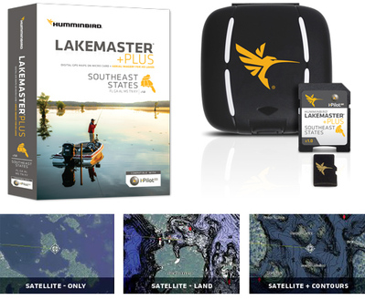
SouthEast PLUS, Version 1
PLUS allows for 3 layers of aerial image overlay on High Definition waters: Satellite Only, Satellite + Land, and Satellite + Contours
Contours for over 570 lakes
128 High Definition lake maps including these newly surveyed waters in stunning HD:
- Strom Thurmond/Wilson,
- Lauderdale* (GA/AL)
- Wheeler, Limestone* (AL)
- Mitchell, Coosa* (AL)
- Cave Run, Rowan* (KY)
- Enid, Yalobusha* (MS)
- Grenada, Grenada* (MS)
- Harris Chain, Lake* (FL)
Visit the PLUS product page for information on product features like i-Pilot Link, images, complete lake list, lake elevations, GPS compatibility and more.
Western States, Version 6
Contours for over 1,050 lakes
Over 90 High Definition lake maps, including these newly surveyed waters in stunning HD:
- Medicine, Siskiyou (CA)
- Flatiron Res., Larimer (CO)
- McClure Res., Santa Fe (NM)
- Lookout Point, Lane (OR)
- Lost Creek, Jackson (OR)
Visit the product page for information on product features like I-Pilot Link, images, complete lake list, GPS compatibility and more.
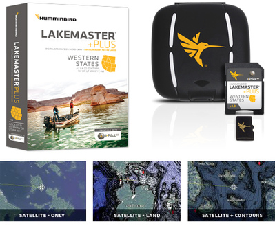
Western States PLUS, Version 1
PLUS allows for 3 layers of aerial image overlay on High Definition waters: Satellite Only, Satellite + Land, and Satellite + Contours.
Contours for over 1,050 lakes
Over 90 High Definition lake maps, including these newly surveyed waters in stunning HD:
- Medicine, Siskiyou (CA)
- Flatiron Res., Larimer (CO)
- McClure Res., Santa Fe (NM)
- Lookout Point, Lane (OR)
- Lost Creek, Jackson (OR)
Visit the PLUS product page for information on product features like i-Pilot Link, images, complete lake list, GPS compatibility and more.
"Join The Leading Crappie News Source"


